


Muscadine, Cleburne County, Alabama
About
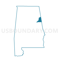
Outline

Summary
| Unique Area Identifier | 521434 |
| Name | Muscadine |
| County | Cleburne County |
| State | Alabama |
| Area (square miles) | 18.62 |
| Land Area (square miles) | 18.60 |
| Water Area (square miles) | 0.02 |
| % of Land Area | 99.89 |
| % of Water Area | 0.11 |
| Latitude of the Internal Point | 33.74036550 |
| Longtitude of the Internal Point | -85.37658540 |
Maps


Graphs
Select a template below for downloading or customizing gragh for Muscadine, Cleburne County, Alabama


Neighbors
Neighoring Voting District (by Name) Neighboring Voting District on the Map
- 14304 - BUNCOMBE Voting District, Haralson County, GA
- 14311 - BEREA-STEADMAN Voting District, Haralson County, GA
- 14312 - TALLAPOOSA Voting District, Haralson County, GA
- Fruithurst City Hall Voting District, Cleburne County, AL
- Oak Level, Cleburne County, AL
- Plainview Fire Department Voting District, Cleburne County, AL
Top 10 Neighboring County Subdivision (by Population) Neighboring County Subdivision on the Map
- Tallapoosa CCD, Haralson County, GA (8,189)
- Ranburne CCD, Cleburne County, AL (4,667)
- Fruithurst CCD, Cleburne County, AL (2,684)
Top 10 Neighboring Place (by Population) Neighboring Place on the Map
Top 10 Neighboring Unified School District (by Population) Neighboring Unified School District on the Map
Top 10 Neighboring State Legislative District Lower Chamber (by Population) Neighboring State Legislative District Lower Chamber on the Map
Top 10 Neighboring State Legislative District Upper Chamber (by Population) Neighboring State Legislative District Upper Chamber on the Map
Top 10 Neighboring 111th Congressional District (by Population) Neighboring 111th Congressional District on the Map
Top 10 Neighboring Census Tract (by Population) Neighboring Census Tract on the Map
- Census Tract 104, Haralson County, GA (7,804)
- Census Tract 102, Haralson County, GA (5,725)
- Census Tract 9598, Cleburne County, AL (4,667)
- Census Tract 9595, Cleburne County, AL (2,684)